
Trails

There are plenty of trails to enjoy throughout the Mark Twain National Forest and we have listed some of our favorites closest to Pine Valley. We also offer a couple of small, private trails on the property for your enjoyment.
Huzzah Creek Trail
The Huzzah Creek trail is a half-mile starting directly across from the entrance at Pine Valley. Take the short walk down to the Huzzah Creek and enjoy a day fishing, swimming, and relaxing by the water.
DISTANCE
.5 miles
ELEVATION GAIN
141ft feet
ROUTE TYPE
Out & Back
Directions - Right across the entrance of Pine Valley
Dillard Mill Walk

Dillard Mill Walk is a 1.4 mile lightly trafficked out and back trail located near Davisville, Missouri that features a lake and is good for all skill levels. The trail offers a number of activity options and is accessible year-round. Dogs are also able to use this trail but must be kept on leash.
DISTANCE
1.4 miles
ELEVATION GAIN
314 feet
ROUTE TYPE
Out & Back
Directions - 2,500 feet from Pine Valley
Bell Mountain Loop Trail
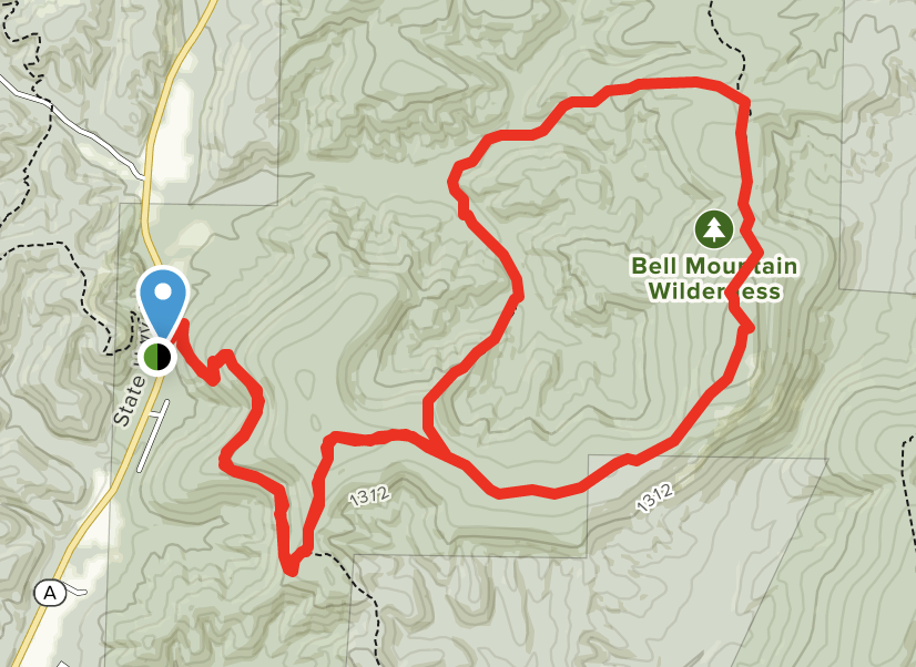
Bell Mountain Loop Trail is a 11.6 mile lightly trafficked loop trail located near Belleview, Missouri that features a river and is rated as moderate. The trail offers a number of activity options and is accessible year-round. Dogs are also able to use this trail but must be kept on leash.
DISTANCE
11.6 miles
ELEVATION GAIN
1,683 feet
ROUTE TYPE
Loop
Directions - 29 miles from Pine Valley
The Ozark Trail: Taum Sauk Section
The Ozark Trail: Taum Sauk Section is a 33.7 mile moderately trafficked point-to-point trail located near Belleview, Missouri that features a lake and is rated as difficult. The trail offers a number of activity options and is accessible year-round. Dogs are also able to use this trail but must be kept on leash.
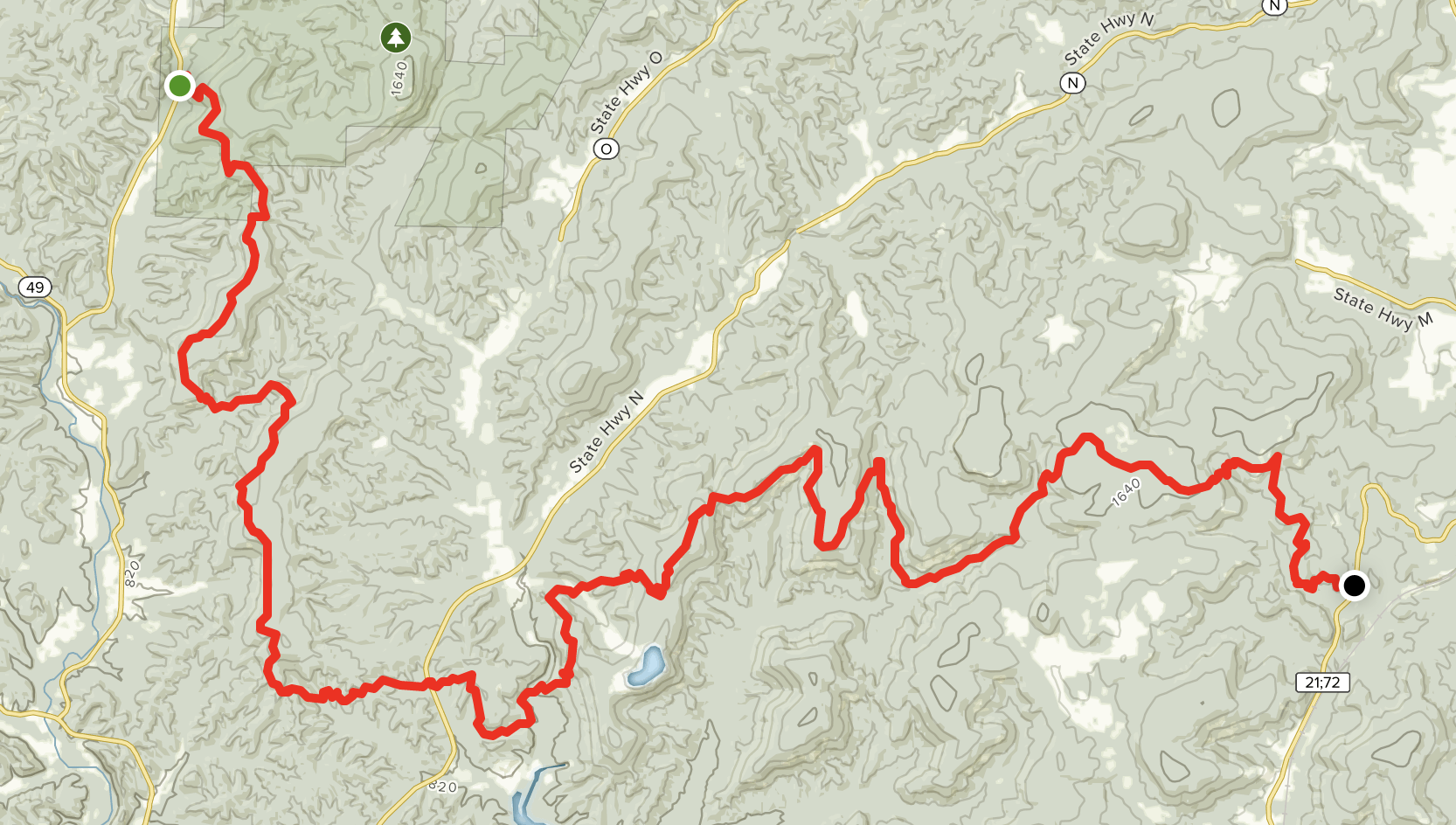
The section is 35 miles in length, but lends itself to two different hikes: one from Highway A to Shut-Ins (15 miles), and the other to Shut-Ins to Taum Sauk (12.5 miles ( although you can continue to Highway 21 for a total of 18 miles). This trail will slow you down– you’ll find your average speed drop a mile-an-hour for your normal pace as you negotiate the rough terrain. One person described the tread as “a natural stair-stepping machine.” Look for the cairns in the igneous glades, as it’s easy to get lost.
DISTANCE
33.7 miles
ELEVATION GAIN
5,370 feet
ROUTE TYPE
Point to Point
Directions - 29 mile drive from Pine Valley
Ozark Trail: Middle Fork Section

Ozark Trail: Middle Fork Section is a 22.7 mile lightly trafficked point-to-point trail located near Belleview, Missouri that features a lake and is rated as moderate. The trail offers a number of activity options and is accessible year-round. Dogs are also able to use this trail but must be kept on leash.
DISTANCE
22.7 miles
ELEVATION GAIN
2,670 feet
ROUTE TYPE
Point to Point
Directions - 21.5 miles from Pine Valley
Council Bluff Lake Trail

Council Bluff Lake Trail is a 10.7 mile lightly trafficked loop trail located near Belleview, Missouri that features a lake and is rated as moderate. The trail offers a number of activity options and is accessible year-round. Dogs are also able to use this trail but must be kept on leash.
DISTANCE
10.7 miles
ELEVATION GAIN
823 feet
ROUTE TYPE
Loop
Directions - 26.5 miles from Pine Valley
The Ozark Trail: Karkaghne Section
The Ozark Trail: Karkaghne Section is a 27.9 mile moderately trafficked point-to-point trail located near Black, Missouri that features a river and is rated as moderate. The trail offers a number of activity options and is accessible year-round. Dogs are also able to use this trail but must be kept on leash.

This is mainly a side-slope trail, running just below the ridge-tops as it snakes its way from Oates to Highway 72, occasionally dipping into the valleys as it crosses the West Fork of the Black River, Bee Fork and a few hollows along the way. Near the southern end of the trail is a side-trip to Grasshopper Hollow, the largest fen complex in non-glaciated North America.
DISTANCE
27.9 miles
ELEVATION GAIN
3,599 feet
ROUTE TYPE
Point to Point
Directions - 34 minute drive from Pine Valley